


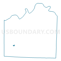
KC WD26 PCT2611, Jackson County, Missouri
About
Outline

Summary
| Unique Area Identifier | 608403 |
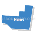
| Name | KC WD26 PCT2611 |
| County | Jackson County |
| State | Missouri |
| Area (square miles) | 0.23 |
| Land Area (square miles) | 0.23 |
| Water Area (square miles) | 0.00 |
| % of Land Area | 100.00 |
| % of Water Area | 0.00 |
| Latitude of the Internal Point | 38.92610730 |
| Longtitude of the Internal Point | -94.51547970 |
Maps


Graphs
Select a template below for downloading or customizing gragh for KC WD26 PCT2611, Jackson County, Missouri


Neighbors
Neighoring Voting District (by Name) Neighboring Voting District on the Map
- KC WD20 PCT2002, Jackson County, MO
- KC WD20 PCT2009, Jackson County, MO
- KC WD25 PCT2506, Jackson County, MO
- KC WD25 PCT2508, Jackson County, MO
- KC WD26 PCT2502, Jackson County, MO
- KC WD26 PCT2610, Jackson County, MO